Large-scale 3D point cloud high-speed editing tool 'Wing Earth'

[Subsidy-eligible products] Thoroughly pursuing production workflows using 3D point clouds! Comfortable processing of large-volume point clouds!
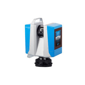
"Wing Earth" is a three-dimensional point cloud processing tool that performs volume calculations, heat map creation, and output of construction acceptance judgment summary tables based on point cloud data obtained through three-dimensional measurement using fixed three-dimensional laser scanners, MMS, etc. This tool is equipped with high-speed three-dimensional point cloud processing capabilities that allow for the loading of point cloud data exceeding 10 billion points, achieving overwhelming high-speed display of point clouds. Additionally, it features the ability to recognize vehicles, people, and signs as a single entity with just a click on a point in the point cloud, enabling fast and easy deletion and management of objects in just a few seconds. [Features] - Capable of handling a wide range of related data, both general and specialized - Visually and intuitively guides users through each step of the process to achieve the desired results with high usability *For more details, please refer to the catalog or PDF materials, or feel free to contact us. ★ This product is a surveying instrument eligible for "subsidy utilization" upon purchase. It may be available for purchase at a price of 1/2 to 1/3 of the regular price! If you are interested, please do not hesitate to contact us. *Condition applies: Purchase must be made simultaneously with the equipment.
basic information
【Other Features】 ■ A wealth of data editing utilities generates flexible output data ■ Prevents rework while enabling various types of deliverables ■ Complies with the guidelines for construction management using aerial photogrammetry (unmanned aerial vehicles) (draft) ■ Easy video creation ■ Export to 3D PDF ■ Comfortable operability in three-dimensional space ■ Effective display function for planar processing: "Edge display of 3D point clouds" ■ Full utilization of survey/design data ■ Roller method filtering & hole filling ■ Point cloud grouping and extraction ■ Automatic object recognition *For more details, please refer to the catalog or PDF materials, or feel free to contact us.
Price range
Delivery Time
Applications/Examples of results
For more details, please refer to the PDF document or feel free to contact us.
catalog(18)
Download All Catalogs


PENTAX G7N GNSS Receiver

PENTAX Total Station "P-100 Series"

PENTAX Mobile 2D Laser Scanner "S-2200C"

PENTAX Ground-type 3D Laser Scanner Mid to Long Range "S-3200V S-3075V"

PENTAX Total Station "X-100 Series"

PENTAX Total Station "V-500 Series"
News about this product(75)
-

[Latest Subsidy Information] IT Introduction Subsidy 2025 First Application Schedule Announcement
The brochure for the IT Implementation Subsidy 2025 has been updated. The support categories for the 2025 fiscal year include the "Standard Category," "Security Measures Promotion Category," "Invoice Category (Invoice-Compatible Type and Electronic Transaction Type)," and "Multiple Company Collaboration IT Implementation Category." Details regarding the maximum subsidy amount and subsidy rate will be updated as soon as they are announced. 【Schedule】 ● Registration application for IT implementation support providers Application period: Starting March 31, 2025 (Monday) (planned) ● Registration application for IT tools (software, services, etc.) Application period: Starting February 28, 2025 (Friday) (planned) ● Grant application period (Standard Category, Invoice Category, Security Measures Category) Application period: Starting March 31, 2025 (Monday) (planned) Deadline: May 12, 2025 (Monday) (planned) Grant decision date: June 18, 2025 (Wednesday) (planned) Project implementation period: From grant decision to December 26, 2025 (Friday) at 17:00 (planned)
-

【Maximum Grant Amount 100 Million Yen!】Information on Grants for the Construction Industry "2nd Emergency Support Program for Capital Investment"
A public call for grants aimed at small and medium-sized enterprises with business locations in Tokyo has begun. This grant is intended to subsidize part of the expenses for introducing machinery and equipment necessary for improving productivity and strengthening competitiveness in response to the "2024 Problem." <Eligible Expenses> Expenses for the introduction of machinery, equipment, and software to address the labor shortages caused by the upper limit regulations on overtime work, known as the "2024 Problem." <Grant Rate and Limit> - Grant Rate: Up to 4/5 - Grant Limit: 100 million yen (Minimum grant amount: 1 million yen) <How to Apply for the Grant> Application Reservation Period: From 9:00 AM on October 23, 2024 (Wednesday) to 5:00 PM on November 6, 2024 (Wednesday) Application Acceptance: From 9:00 AM on November 1, 2024 (Friday) to 5:00 PM on November 15, 2024 (Friday) *Applications will be accepted through the electronic system "J-Grant" provided by the national government (Digital Agency). We will provide thorough support from preparation before application, equipment introduction, to confirmation of grant payment. *For more details, please refer to the catalog or PDF materials, or feel free to contact us.
-

[New Service] '3D Measurement Service' utilizing ground-based laser scanners.
We can acquire 3D point cloud data using our terrestrial and handheld laser scanners. Additionally, we offer GNSS surveying services and can accommodate requests for RTK surveying and static surveying as needed! 【Features of 3D Measurement Services】 - Smooth support from meetings to the field - Delivery of 3D point cloud data in the requested data format - Data delivery within as little as 2 business days* (Delivery time may vary depending on the size of the site.) 【Main Equipment Used】 - Leica RTC360 - Leica BLK G2 - Leica BLK 2GO - Leica GS18 I - Leica GS18 T - Leica GS07 We have a proven track record in various scenes such as roads and fields. Please feel free to consult with us!
-

Kanagawa Prefecture: Subsidy Information - Subsidy for the Promotion of Productivity Improvement in Small and Medium-sized Enterprises for Fiscal Year 2024
<Eligible Recipients> Small and medium-sized enterprises as defined in Article 2, Paragraph 1 of the "Small and Medium-sized Enterprise Support Act (Law No. 147 of 1963)" that have a business office in Kanagawa Prefecture. <Eligible Expenses> - Machinery and equipment costs, IT service implementation costs, facility construction costs <Subsidy Limit and Rate> 5 million yen (rounded down to the nearest thousand) / up to 1/2 <Application Acceptance Period> August Deadline: August 1, 2024 (Wednesday) 9:00 AM to August 30, 2024 (Friday) 5:00 PM September Deadline: September 2, 2024 (Monday) 9:00 AM to September 30, 2024 (Monday) 5:00 PM For inquiries about introducing cutting-edge equipment using subsidies, please feel free to contact Yokohama Sokkiki!
-

[Tokyo Metropolitan Government: Subsidy Information] Support Program for Business Development Responsive to New Business Environments
<Eligible Recipients> Small and medium-sized enterprises in Tokyo (including sole proprietors) whose sales in the most recent fiscal period have decreased compared to any fiscal period after the fiscal period of 2019, or who have recorded losses in the most recent fiscal period. <Eligible Expenses> Expenses recognized in the review when a plan to deepen and develop existing businesses has been created. <Grant Limit and Grant Rate> 8 million yen (rounded down to the nearest thousand yen) / within 2/3 of eligible expenses. <Application Acceptance Period> Scheduled to be conducted monthly until March of the 7th year of Reiwa. For inquiries about the introduction of cutting-edge equipment utilizing grants, please feel free to contact Yokohama Soki!
Distributors

Yokohama Measuring Instruments Co., Ltd. is engaged in the sale, repair maintenance, and rental of surveying instruments (general surveying instruments, GNSS, laser scanners, etc.), surveying CAD software, multifunction office equipment, and other related products. We offer a lineup of products from various manufacturers such as Leica, Topcon Sokkia, and Pentax. Please feel free to contact us if you have any requests. We have established a new consulting division to support subsidy applications. We provide support for subsidy applications such as the "Monozukuri Subsidy" and the "Business Restructuring Subsidy." We also offer support for the introduction of high-value equipment utilizing subsidies! Our company will comprehensively support the necessary business plans and application procedures required for the application. If you have any other questions, please do not hesitate to let us know.