GNSS receiver equipped with a pile driving camera

"Photogrammetry function" and "equipped with a laser rangefinder" expand the scope of one-man surveying!
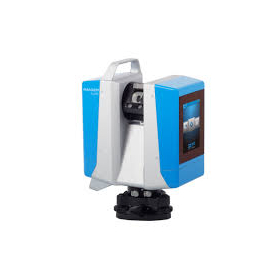
Three types of GNSS series tailored to needs All models are equipped with a downward-facing camera for piling 1. GX2-A (Camera for piling) 2. GX2-L (Camera for piling + Laser rangefinder) 3. GX2-C (Camera for piling + Laser rangefinder) Photogrammetry
basic information
■Main Features (Common to All 3 Models) - Equipped with a high-performance satellite reception board (high-precision positioning module) with 1408 channels, capable of receiving signals from GPS, GLONASS, GALILEO, BEIDOU, and QZSS. - Achieves network RTK observation without cables, allowing data from reference points or virtual reference points on the network to be obtained from a distribution server. - Includes tilt correction function, which allows real-time coordinate correction using a tilt sensor within a range of ±60°. - The easy-to-read display on the main unit shows network connection status, battery level, number of satellites, and location information, indicating that the GNSS receiver is receiving signals from satellites. - Controller app PTS (standard included) features photo capture and map display functions for convenience. - Data can be output in a proprietary format and with a RINEX extension.
Price range
Delivery Time
Model number/Brand name
PENTAX GX2 Series
Applications/Examples of results
In measurements within hard-to-access areas such as fences and the edges of central reservations, photogrammetry functions and laser rangefinders can be used to measure points from a distance. This expands the scope of work beyond that of a standard GNSS receiver.
catalog(2)
Download All Catalogs

Distributors

Yokohama Measuring Instruments Co., Ltd. is engaged in the sale, repair maintenance, and rental of surveying instruments (general surveying instruments, GNSS, laser scanners, etc.), surveying CAD software, multifunction office equipment, and other related products. We offer a lineup of products from various manufacturers such as Leica, Topcon Sokkia, and Pentax. Please feel free to contact us if you have any requests. We have established a new consulting division to support subsidy applications. We provide support for subsidy applications such as the "Monozukuri Subsidy" and the "Business Restructuring Subsidy." We also offer support for the introduction of high-value equipment utilizing subsidies! Our company will comprehensively support the necessary business plans and application procedures required for the application. If you have any other questions, please do not hesitate to let us know.