- PRODUCT
High-precision RTK-GNSS available for a monthly fee of several thousand yen: 'ichimill' thoroughly tested by Kōbe Seiko for drone surveying and point cloud measurement.
ソフトバンク 本社
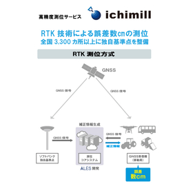
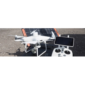
This article was published in Construction IT World on March 18, 2022. SoftBank offers a high-precision positioning service called "ichimill," which provides "correction information" used in "RTK-GNSS" capable of high-precision surveying. Despite its accuracy of just a few centimeters, the usage fee is surprisingly low at several thousand yen per month. A technical sales representative from Kobe Seiko, a surveying equipment sales company based in Kobe, Hyogo Prefecture, thoroughly tested the capabilities of ichimill using point cloud measurements with drones and 3D laser scanners.

- Date and time
- Capital
- Entry fee
Related Documents
Related Links
High-precision RTK-GNSS available for a monthly fee of several thousand yen: 'ichimill' Kobe Seiko thoroughly verifies drone surveying and point cloud measurement | Business Blog | SoftBankRelated product information
-
High-precision positioning service for measurement "ichimill"Achieving positioning with an error of a few centimeters. Improving the accuracy of terrain mapping.
【Features】 - Achieves high-precision positioning with an error of a few centimeters using RTK technology - Utilizes GNSS signals such as the quasi-zenith satellite "Michibiki" - Over 3,300 proprietary reference points established by SoftBank nationwide - Easy to implement without the need for customers to set up their own reference stations - Offers the "Ntrip (G-VRS) plan" compatible with public surveying 【Our Strengths】 SoftBank proposes the construction of society and industry through DX under the concept of "a world where all things, information, and hearts are connected." Based on the technology and infrastructure cultivated through mobile communication services and internet connectivity services, we support corporate DX and provide four foundations necessary for digitalization: communication, automation, marketing, and security. As part of this DX promotion, ichimill provides high-precision positioning technology, contributing to the efficiency and accuracy improvement in the surveying industry.
-
High-precision positioning service "ichimill" for infrastructure inspectionPositioning with an error of a few centimeters in drone aerial photography. Over 3,300 unique reference points nationwide.
【Features】 1. Over 3,300 SoftBank unique reference points established nationwide: SoftBank has densely established its unique reference points at over 3,300 locations across the country as fixed stations necessary for RTK positioning. Customers can easily implement this without the need to set up their own reference stations. 2. Service type: We also provide correction information distribution services via Ntrip, allowing for usage tailored to customer needs. 3. Visualization through a web management system: With the GNSS receiver and web management system (WEB-UI), it is possible to check the current location and movement trajectory of devices using a PC or smartphone. API integration allows for collaboration and utilization with various data. 【Our Strengths】 SoftBank proposes the construction of society and industry through DX under the concept of "a world where all things, information, and hearts are connected." As support for corporate DX, we provide four foundations: communication, automation, marketing, and security, along with mobile communication services and internet connectivity services.
-
Centimeter-level positioning service for dronesSupport for precise drone flight with RTK technology.
【Features】 - High-precision positioning with an error of a few centimeters using RTK technology - Utilization of SoftBank's unique reference points (base stations) - Distribution of correction information via the internet (Ntrip method) - Integration with GNSS receivers through smartphones is possible - Offered to individual customers 【Our Strengths】 SoftBank proposes the construction of society and industry through DX under the concept of "a world where all things, information, and hearts are connected." We provide mobile communication services, mobile device sales, fixed communication services, and internet connection services, offering four foundations necessary for digitalization: communication, automation, marketing, and security, to support companies in their DX efforts.
-
Centimeter-level positioning service for surveyingHigh-precision positioning with an error of a few centimeters for terrain mapping.
【Features】 - High-precision positioning with an error of a few centimeters using RTK technology - Correction information distribution utilizing SoftBank's unique reference points - Real-time distribution via the internet (Ntrip method) - Correction information linkage to GNSS receivers through smartphones - Offered for individual customers 【Our Strengths】 SoftBank proposes the construction of society and industry through DX under the concept of "a world where all things, information, and hearts are connected." We provide mobile communication services, mobile device sales, fixed communication services, and internet connection services, offering four foundations necessary for digitalization: communication, automation, marketing, and security, to support companies in their DX efforts.
-
Centimeter-level positioning service for agricultureHigh-precision positioning with an error of a few centimeters that supports precise distribution.
【Features】 - Achieves high-precision positioning with an error of a few centimeters using RTK technology - Correction information distribution via SoftBank's unique reference points and ALES distribution system - Compatible with GNSS receivers that can be mounted on agricultural machinery, construction equipment, autonomous vehicles, drones, etc. - Correction information distribution via the internet (Ntrip method) - Integration with GNSS receivers via smartphone is possible 【Our Strengths】 SoftBank proposes the construction of society and industry through DX under the concept of "a world where all things, information, and hearts are connected." Based on the communication technologies cultivated through mobile communication services and internet connection services, we provide four foundations for supporting our customers' DX: communication, automation, marketing, and security.
-
Centimeter-level positioning service for construction sitesImproving construction site construction accuracy with RTK technology.
【Features】 - Achieves high-precision positioning with an error of a few centimeters using RTK technology - Collaborates with SoftBank's unique reference points to deliver stable correction information - Distributes correction information to GNSS receivers via the internet (Ntrip method) - Allows for correction information integration through smartphones - Offered to individual customers 【Our Strengths】 SoftBank proposes the construction of society and industry through DX under the concept of "a world where all things, information, and hearts are connected." Based on the technology and infrastructure cultivated through mobile communication services and internet connectivity services, we provide four essential foundations for digitalization—communication, automation, marketing, and security—as support for companies' DX initiatives.
-
High-precision positioning service "ichimill" that solves challenges in the construction industry.High-precision positioning service "ichimill" that solves challenges in the construction industry - A VRS plan that can also accommodate public surveying is now available.
Positioning method: RTK positioning using GNSS signals Positioning accuracy: Error of a few centimeters Supported satellites: GPS, QZSS, GLONASS, Galileo, BeiDou, etc. Reference points: Over 3,300 proprietary reference points established nationwide by SoftBank Features: No need for customers to install or maintain reference points Wide-area use: Automatic switching to the optimal reference point according to movement Provision method: Ntrip method For public surveying: Ntrip (G-VRS) service compatible with public surveying specifications Main applications: Construction machinery, drones, agriculture, private surveying, public surveying, infrastructure surveys Management functions: Position visualization, history checking, and terminal management possible with a web management system Data storage: Stored in the cloud for 90 days, downloadable in XML/CSV format Positioning cycle: Display on the web management system is 1Hz Usage conditions: Intended for use in outdoor environments with open skies Free trial: Available for 1 week
-
Launch of New Plan for Corporate High-Precision Positioning Service "ichimill"New "Ntrip (G-VRS) Plan" for ichimill: Now Compatible with Public Surveying
We offer positioning method contracts tailored to your specific application. You can choose between the "Ntrip Plan" (RRS method using SoftBank's proprietary reference points) and the "Ntrip (G-VRS) Plan" (VRS method using GSI Electronic Reference Points). 【Ntrip Plan】 (RRS Method) - Centimeter-level accuracy via RTK technology. - Utilizes a high-density network of proprietary reference points. - Enables automation across various industries through high-precision positioning. 【Ntrip (G-VRS) Plan】 (VRS Method) - Uses data from Electronic Reference Points to generate virtual reference stations and distribute correction data. - Compliant with "Basic Surveys," "Public Surveys," and "Surveys other than Basic and Public Surveys" as defined by the Survey Act. - For more details, please download the PDF or feel free to contact us. Price: Please refer to the price listed on the page. Delivery: Please contact us for details.