High-precision positioning service for measurement "ichimill"


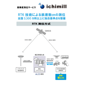
Achieving positioning with an error of a few centimeters. Improving the accuracy of terrain mapping.
In the surveying industry, particularly in terrain mapping, the acquisition of detailed and accurate terrain data is essential. Even slight positioning errors can affect the recognition of terrain shapes and dimensions, potentially leading to rework during the design and development stages, as well as discrepancies with the actual site. High-precision positioning serves as the foundation for reliable terrain data. The high-precision positioning service "ichimill" addresses this challenge by providing positioning accuracy within a few centimeters, thereby supporting more reliable terrain mapping. 【Usage Scenarios】 - Extensive terrain surveying - Acquisition of detailed terrain data - Collaboration with drone surveying - Current condition surveying at construction sites 【Benefits of Implementation】 - Improved accuracy of terrain data - Increased efficiency of surveying operations - Enhanced reliability during design and development stages - Reduction of rework
basic information
【Features】 - Achieves high-precision positioning with an error of a few centimeters using RTK technology - Utilizes GNSS signals such as the quasi-zenith satellite "Michibiki" - Over 3,300 proprietary reference points established by SoftBank nationwide - Easy to implement without the need for customers to set up their own reference stations - Offers the "Ntrip (G-VRS) plan" compatible with public surveying 【Our Strengths】 SoftBank proposes the construction of society and industry through DX under the concept of "a world where all things, information, and hearts are connected." Based on the technology and infrastructure cultivated through mobile communication services and internet connectivity services, we support corporate DX and provide four foundations necessary for digitalization: communication, automation, marketing, and security. As part of this DX promotion, ichimill provides high-precision positioning technology, contributing to the efficiency and accuracy improvement in the surveying industry.
Price range
Delivery Time
Applications/Examples of results
Related to autonomous vehicles, transportation, agriculture, ships, drones, construction equipment, surveying, mapping, robots, infrastructure monitoring, infrastructure inspection and maintenance, public surveying, etc.
catalog(7)
Download All Catalogs


News about this product(1)
Distributors

Support for Corporate DX Providing the four foundations necessary for digitalization 1. Communication Improvement of the work environment / Cloud-based information / Robust network communication 2. Automation Automation of routine tasks / Creation of workforce / Productivity enhancement 3. Marketing Data collection and integration / Analysis and visualization of customer profiles / Advertising distribution and effectiveness measurement 4. Security Building secure networks / Latest malware countermeasures / Utilization of secure cloud services