High-precision positioning service "ichimill" for infrastructure inspection

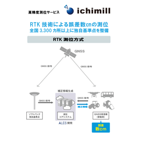
Positioning with an error of a few centimeters in drone aerial photography. Over 3,300 unique reference points nationwide.
In infrastructure inspections, particularly in drone aerial photography, accurate location identification and high-precision data acquisition are required. This enables the efficiency of inspection work and allows for detailed situation analysis. High-precision positioning enhances the reliability of inspection data and becomes an important decision-making material in infrastructure maintenance management. The high-precision positioning service "ichimill" was developed to meet these needs. 【Usage Scenarios】 - Drone aerial inspections of extensive infrastructure facilities - Data collection based on detailed location information of structures - Positioning to enhance the accuracy of inspection data 【Effects of Implementation】 - Increased efficiency and accuracy of inspection work - Deepened data analysis based on detailed location information - Decision-making support in infrastructure maintenance management
basic information
【Features】 1. Over 3,300 SoftBank unique reference points established nationwide: SoftBank has densely established its unique reference points at over 3,300 locations across the country as fixed stations necessary for RTK positioning. Customers can easily implement this without the need to set up their own reference stations. 2. Service type: We also provide correction information distribution services via Ntrip, allowing for usage tailored to customer needs. 3. Visualization through a web management system: With the GNSS receiver and web management system (WEB-UI), it is possible to check the current location and movement trajectory of devices using a PC or smartphone. API integration allows for collaboration and utilization with various data. 【Our Strengths】 SoftBank proposes the construction of society and industry through DX under the concept of "a world where all things, information, and hearts are connected." As support for corporate DX, we provide four foundations: communication, automation, marketing, and security, along with mobile communication services and internet connectivity services.
Price range
Delivery Time
Applications/Examples of results
Related to autonomous vehicles, transportation, agriculture, ships, drones, construction equipment, surveying, mapping, robots, infrastructure monitoring, and infrastructure inspection and maintenance.
catalog(7)
Download All Catalogs


News about this product(2)
-
High-precision RTK-GNSS available for a monthly fee of several thousand yen: 'ichimill' thoroughly tested by Kōbe Seiko for drone surveying and point cloud measurement.
This article was published in Construction IT World on March 18, 2022. SoftBank offers a high-precision positioning service called "ichimill," which provides "correction information" used in "RTK-GNSS" capable of high-precision surveying. Despite its accuracy of just a few centimeters, the usage fee is surprisingly low at several thousand yen per month. A technical sales representative from Kobe Seiko, a surveying equipment sales company based in Kobe, Hyogo Prefecture, thoroughly tested the capabilities of ichimill using point cloud measurements with drones and 3D laser scanners.
-

Enabling the detection of water pipe joint positions with an error margin of a few centimeters. Achieving the digitalization of piping construction management through the utilization of location information.
Currently, the construction and infrastructure industry is facing serious issues such as a shortage of personnel and an aging workforce. The water supply, which is the most important infrastructure supporting our lives, is also confronted with various challenges, including the aging of facilities, a decrease in the number of staff, and an aging workforce among contractors. To maintain and manage water supply facilities, improving efficiency on-site is more essential than ever. To address this issue, Nishio Rent All, a construction equipment rental company, has developed the "HAIKAN-SmartWork" piping construction information management system, which allows for the identification and management of the location of buried water pipes based on signals received from GNSS.
Distributors

Support for Corporate DX Providing the four foundations necessary for digitalization 1. Communication Improvement of the work environment / Cloud-based information / Robust network communication 2. Automation Automation of routine tasks / Creation of workforce / Productivity enhancement 3. Marketing Data collection and integration / Analysis and visualization of customer profiles / Advertising distribution and effectiveness measurement 4. Security Building secure networks / Latest malware countermeasures / Utilization of secure cloud services


