Rivers, ports, disaster prevention

Rivers, ports, disaster prevention
Due to the recent abnormal weather patterns, it is time to fundamentally reassess our flood control and disaster prevention measures. We will continue to create a "resilient society" from both hard and soft perspectives in terms of disaster prevention and mitigation.
1~7 item / All 7 items
-

High-precision 3D mobile laser measurement 'MMS'
It is possible to recognize the interior of tunnels and signs that could not be identified through aerial photogrammetry!
last updated
-

Road Surface Profiling System 'LCMS+MMS'
Cost reduction through simultaneous measurement of road surface condition surveys and mobile mapping!
last updated
-

Investigation of pavement conditions within port facilities and three-dimensional measurement of the facilities.
In March 2024, it was certified by the Ministry of Land, Infrastructure, Transport and Tourism as a "new inspection technology for port facilities"!
last updated
-
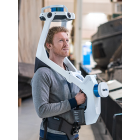
Wearable measurement device "NavVis VLX"
High-speed 3D scanning! With two multi-LiDAR sensors, survey-grade point clouds can be measured just by walking.
last updated
-

UAV-mounted laser measurement system "Air Scanner1"
We provide total support from sales to maintenance.
last updated
-

3D viewer software 'S3S' equipped with CAD functionality.
Available for introduction at 100,000 yen per year (excluding tax)! Software that can incorporate and visualize MMS data, UAV survey data, web maps, 360° images, and more.
last updated
-

Contract for flood simulation (hydraulic analysis and runoff analysis services)
Flexible and realistic flood control measures are possible! Our specialized technology can provide consistent support from investigation to implementation.
last updated