Transportation and Urban Planning

Transportation and Urban Planning
We are working on technical proposals aimed at ensuring safety and security, improving convenience, and advancing and streamlining maintenance management, using new insights to address the diverse needs of cities and roads that support daily life and economic activities.
1~6 item / All 6 items
-

High-precision 3D mobile laser measurement 'MMS'
It is possible to recognize the interior of tunnels and signs that could not be identified through aerial photogrammetry!
last updated
-

Road Surface Profiling System 'LCMS+MMS'
Cost reduction through simultaneous measurement of road surface condition surveys and mobile mapping!
last updated
-
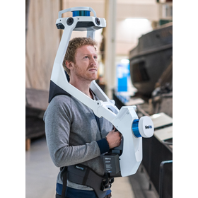
Wearable measurement device "NavVis VLX"
High-speed 3D scanning! With two multi-LiDAR sensors, survey-grade point clouds can be measured just by walking.
last updated
-

UAV-mounted laser measurement system "Air Scanner1"
We provide total support from sales to maintenance.
last updated
-

Cloud service "RID" for the maintenance management of road facilities.
Open data for digital twin infrastructure for local governments! Specify the point cloud to be displayed on the map!
last updated
-

3D viewer software 'S3S' equipped with CAD functionality.
Available for introduction at 100,000 yen per year (excluding tax)! Software that can incorporate and visualize MMS data, UAV survey data, web maps, 360° images, and more.
last updated