All products and services
1~30 item / All 108 items
-
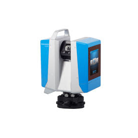
High-Quality 3D Laser Scanner Z+F IMAGER Series
Incredible measurement accuracy and speed. Utilize subsidies to realize DX for point cloud data right now! Z+F IMAGER 5024 series.
last updated
-

Mobile Handheld Scanner HS-X1
A handheld LiDAR scanner equipped with GNSS receivers and SLAM technology, capable of acquiring high-precision point cloud data both indoors and outdoors.
last updated
-

Subsidy application service
Recommended for surveyors, land and house investigators, and those in construction and civil engineering! Support is available nationwide.
last updated
-

CAD system "ANIST"
Complete the creation of floor plans from point cloud data in a single app.
last updated
-

[Subsidy Application Support] Labor-Saving Investment Subsidy
The subsidy application for measuring equipment has an acceptance rate of over 90%! We have supported more than 100 companies!
last updated
-

Mobile Mapping SLAM Laser Scanner
A mobile measurement system equipped with the Z+F IMAGER5016 in a "backpack"!
last updated
-

GNSS receiver equipped with a pile driving camera
"Photogrammetry function" and "equipped with a laser rangefinder" expand the scope of one-man surveying!
last updated
-

Tilt correction and lightweight! GNSS smart antenna 'Leica GS05'
No calibration needed! GNSS antenna with tilt correction function up to 30 degrees.
last updated
-
![イプロス用補助金表紙 [自動保存済み].jpg](https://image.www.ipros.com/public/product/image/90a/2001508111/IPROS11255775963328146449.jpg?w=280&h=280)
Proposal for a New Surveying Method: Remote Surveying System with Video!
Remote Measurement System: Towards solving the issues of technical inheritance, labor reduction, and efficiency at the site!
last updated
-

【Highly Anticipated】Yokohama Measuring Instruments Provides Strong Support for the Introduction of Advanced Equipment Utilizing Subsidies
Are you considering introducing advanced surveying equipment such as laser scanners, GNSS, and sonar using subsidies? Yokohama Instruments will support you!
last updated
-

[Subsidy-eligible product] UAV and laser surveying system 'UL-3'
Acquire 3D data of a wide area of the surface in a short time. Suitable for shortening construction periods and reducing labor.
last updated
-

TOPCON: 3D Laser Scanner 'ESN-100'
Easily automate measurements and ensure reliable data acquisition!
last updated
-

3D Measurement Service Utilizing Ground-Based Laser Scanners
We provide 3D measurement services using ground-based laser scanners! We can accommodate various sites such as factories, plants, and fields.
last updated
-

Remote Presence Business Use Compact Wearable Camera
[Ministry of Land, Infrastructure, Transport and Tourism NETIS Registered Product] Can be checked via live video from the company without going to the site.
last updated
-

『Leica AP20 AutoPole』
[Special Campaign Now!] Breaking Common Sense! The World's First Prism Ball That Can Be Measured by Tilting!
last updated
-

[Eligible for IT Introduction Subsidy!] Wingneo INFINITY 2025
Announcement of the launch of the latest version of CAD software "Wingneo INFINITY 2025" for the surveying, civil engineering design, and registration industries.
last updated
-

Fully autonomous flying laser scanner "Leica BLK2FLY"
Orders will start in Japan from March 1, 2024! Fully autonomous flying laser scanner Leica BLK2FLY.
last updated
-

High positioning performance and lightweight design for faster surveying work! GNSS receiver
High positioning performance and a simple interface will change surveying work!
last updated
-

Mobile 2D Scanner 'S-2200C/S-2200'
Adapted for high-speed movement, optimal for infrastructure inspection! Measures approximately 2 million points per second, "acquires color point clouds."
last updated
-

PENTAX: Total Station "X-100D Series"
Equipped with "camera function" and "Android device"
last updated
-

PENTAX: Total Station "P-100 Series"
Fast," "Accurate," "High cost performance
last updated
-

PENTAX: Total Station "V-500 Series"
Non-prism distance measurement standard model with enhanced features, 500m.
last updated
-

GNSS:『Leica Viva GS16』
Lightweight GNSS Smart Antenna for Accurate Positioning
last updated
-

TOPCON:GNSS『HiPer SR』
Compact and lightweight all-in-one receiver suitable for both measurement and civil engineering.
last updated
-

GNSS Smart Antenna 'Leica GS07'
Lightweight and the most compact GNSS smart antenna
last updated
-

"LupoScan," specialized in structured laser scan data processing.
Software that efficiently creates floor plans by integrating 2D/3D CAD, point cloud analysis, and GIS.
last updated
-

Point cloud tracing and analysis software "Pythagoras"
Software that efficiently creates floor plans by integrating 2D/3D CAD, point cloud analysis, and GIS.
last updated
-

[Subsidy-eligible product] UAV and laser surveying system 'UL-2'
Acquisition of realistic 3D colored point clouds with built-in long-range scanner.
last updated
-

PENTAX: Ground-type 3D laser scanner "S-3200V"
Capable of measuring a wide area in a short time! Ground-based 3D laser scanner, medium to long range type.
last updated
-

TS measurement and scanner model TOPCON GTL-1200
Solve the challenges of 3D point cloud measurement with an on-site completion workflow!
last updated